Remote Sensing of Nature
Measuring the world's forest carbon and biodiversity is made possible by remote
sensing instruments, ranging from satellites in space (Landsat, Sentinel, GEDI)
to ground-based sensors (ecoacoustics, camera traps, moisture sensors) that
take regular samples and are processed into time-series metrics and actionable
insights for conservation and human development. However, the algorithms for
processing this data are challenging as the data is highly multimodal
(multispectral, hyperspectral, synthetic aperture radar, or lidar), often
sparsely sampled spatially, and not in a continuous time series. I work on
various algorithms and software and hardware systems we are developing to
improve the datasets we have about the surface of the earth, in close
collaboration with the
Mapping nature on earth
Figuring out where things live on the planet's surface from satellites requires a lot of data processing, and tricks to work around the fact that we can't easily see through clouds (when using optical sensors) or handle very sloped surfaces (if using lidar) or peek through the top of a dense forest canopy (especially in tropical forests). Along with colleagues in the Cambridge Centre for Earth Observation, I've been working on a few projects that aim to improve the quality of the data we have about the surface of the earth.
The main research question we're tackling is how to improve our knowledge about where most wild species live on the planet, so that we can better protect their receding habitats. And in particular, our knowledge of where rare plant species live is surprisingly data deficient.
Geospatial Foundation Models with TESSERA
A breakthrough in our remote sensing work came in 2025 with
Foundation models represent a paradigm shift for remote sensing: instead of
training new models from scratch for every downstream task (crop
classification, forest height estimation, biomass calculations), TESSERA's
pre-trained embeddings can be used directly as features. This
"embedding-as-data" approach democratises access to advanced remote sensing
analytics, making it feasible for ecologists without deep ML expertise to build
sophisticated classifiers. See
TESSERA is trained only on public ESA satellite data and we make the embeddings
freely available, aligning with our commitment to open science. The model has
been evaluated on diverse tasks from wildfire detection to forest stock
estimation, and we presented the programming challenges around planetary-scale
embeddings at
Satellite and Drone Sensing of Tree Species
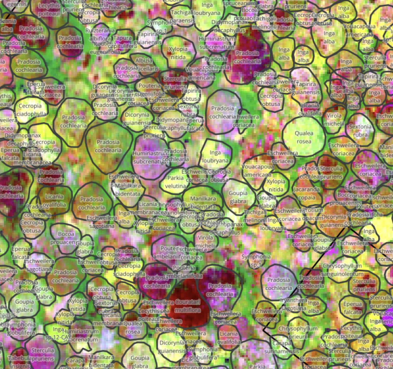
Old-growth tropical trees have the big advantage of being relatively easily
visible from the air, and we've been developing a robust satellite and drone
processing pipeline as part of the

Read more about it in the "
Biodiversity Metrics from Remote Sensing Data
The remote sensing data we collect feeds directly into biodiversity impact
metrics. Our work on Area of Habitat (AoH) maps, Species Distribution Models,
and applications like the LIFE metric that quantifies species extinction risks
from land-cover changes, is covered in detail in the
Coordinating Global Biodiversity Observations
Our work on remote sensing feeds into broader efforts to coordinate
biodiversity monitoring at global scale. Through collaboration with the Global
Biodiversity Observation Network (GEO BON) and their "BON in a Box" platform
(see
The urgency of the Kunming-Montreal Global Biodiversity Framework demands
harmonized monitoring approaches. Our contribution to the
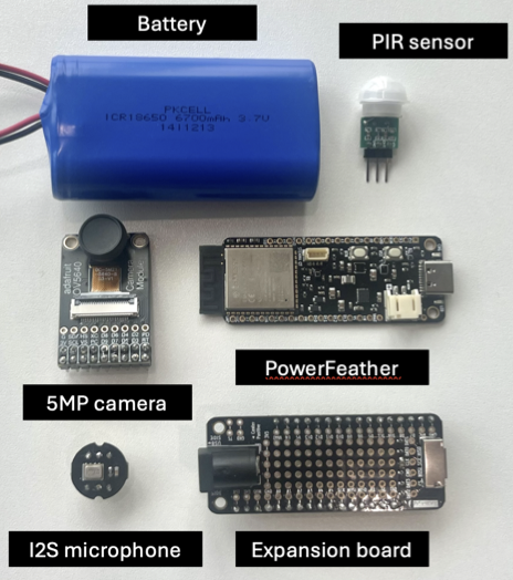
Ground-Based Sensing with the Terracorder

In 2024, I started collaborating with
Since I've been exploring spatial networking with Josh and
The spatial coordination challenge extends beyond power management to network
architecture itself. Our
Applications to Human Health and Urban Nature
Ultimately, it would also be nice to understand the impact of more natural
spaces on human health as well. After all, we not only need to protect
unspoilt nature, but also need to make sure that highly urbanised areas are
liveable.
We began this work by analyzing the 3-30-300 urban greening rule across major
UK cities in
This framework establishes a reproducible, open, and computationally efficient
blueprint for evaluating urban nature equity at scale, supporting the
integration of environmental justice metrics into national urban planning
agendas. Read more about the broader project at
Activity
2025 Advent of Agentic Humps: Building a useful O(x)Caml library every day – Research note (Dec 2025)
On the path to the UK/India AI Summit with OpenUK and the ATI – Research note (Nov 2025)
BIOMASS launches to measure forest carbon flux from space – Research note (Jun 2025)
EEG internships for the summer of 2025 – Research note (Jun 2025)
Visiting National Geographic HQ and the Urban Exploration Project – Research note (Jun 2025)
Semi distributed filesystems with ZFS and Sanoid – Research note (Apr 2025)
3D printing the planet (or bits of it) – Research idea (ongoing, Any level, Apr 2025)
Programming FPGAs using OCaml – Research note (Feb 2025)
Satellites are getting too good for forest carbon? – Research note (Feb 2025)
Using computational SSDs for vector databases – Research idea (available, MPhil level, Feb 2025)
Building species models of the planet – Research note (Sep 2024)
Using wasm to locally explore geospatial layers – Research idea (ongoing, PartII level, Aug 2024)
COMPASS 2024 report on the CoRE stack RIC meeting – Research note (Jul 2024)
Composable diffing for heterogenous file formats – Research idea (expired, MPhil level, Jan 2024)
Planetary Computing – Project (2022–present)
Trusted Carbon Credits – Project (2021–present)
References
TESSERA: Temporal Embeddings of Surface Spectra for Earth Representation and Analysis
Frank Feng, Clement Atzberger, Sadiq Jaffer, Jovana Knezevic, Silja Sormunen, Robin Young, Madeline Lisaius, Markus Immitzer, Toby Jackson, James G. C. Ball, David Coomes, Anil Madhavapeddy, Andrew Blake, and Srinivasan Keshav.
Working paper at arXiv.
Nine changes needed to deliver a radical transformation in biodiversity measurement
Bill Sutherland, Neil Burgess, Scott Edwards, Julia P.G. Jones, Pamela S. Soltis, David Tilman, Julie M. Allen, Herizo T. Andrianandrasana, Tom August, Kamal Bawa, Sallie Bailey, Tanya Birch, Philipp Boersch-Supan, Jeannine Cavender-Bares, Mark Blaxter, Rebecca Chaplin-Kramer, Barnabus H. Daru, Adriana de Palma, Cristina Eisenberg, Chris Elphick, Rob Freckleton, Winifred F. Frick, Andrew Gonzalez, Scott Goetz, Lior Greenspoon, Christina M. Grozinger, Don L. Hankins, Jonny Hazell, Nick J. B. Isaac, Marco Lambertini, Harris A. Lewin, Oisin Mac Aodha, Anil Madhavapeddy, E. J. Milner-Gulland, James P. O'Dwyer, Andy Purvis, Nick Salafsky, Heather Tallis, Iroro Tanshi, Varsha Vijay, Martin Wikelski, David Williams, Hollis Woodard, and Gene E. Robinson.
Working paper at EcoEvoRxiv.
From Data to Decisions: Towards a Biodiversity Monitoring Standards Framework
Andrew Gonzalez, Tom August, Sallie Bailey, Kyle Bobiwash, Philipp Boersch-Supan, Neil Burgess, Barnabus H. Daru, Chris Elphick, Rob Freckleton, Winifred F. Frick, Alice C. Hughes, Nick J. B. Isaac, Julia P.G. Jones, Marco Lambertini, Oisin Mac Aodha, Anil Madhavapeddy, E. J. Milner-Gulland, Andy Purvis, Nick Salafsky, Bill Sutherland, Iroro Tanshi, Varsha Vijay, Hollis Woodard, and David Williams.
Working paper at EcoEvoRxiv.
Energy-Aware Deep Learning on Resource-Constrained Hardware
Josh Millar, Hamed Haddadi, and Anil Madhavapeddy.
Working paper at arXiv.
Conservation changed but not divided
Sam Reynolds, Sara Beery, Neil Burgess, Mark Burgman, Stuart Butchart, Steven J. Cooke, David Coomes, Finn Danielsen, Enrico Di Minin, América Paz Durán, Amy Hinsley, Sadiq Jaffer, Julia P.G. Jones, Binbin V. Li, Anil Madhavapeddy, Lloyd Peck, Nathalie Pettorelli, Jon Paul Rodríguez, and Bill Sutherland.
Journal paper in Trends in Ecology & Evolution.
Terracorder: Sense Long and Prosper
Josh Millar, Sarab Sethi, Hamed Haddadi, and Anil Madhavapeddy.
Working paper at arXiv.
PACT Tropical Moist Forest Accreditation Methodology v2.1
Andrew Balmford, David Coomes, Michael Dales, Patrick Ferris, James Hartup, Sadiq Jaffer, Srinivasan Keshav, Miranda Lam, Anil Madhavapeddy, Robin Message, E.-Ping Rau, Thomas Swinfield, Charlotte Wheeler, and Abby Williams.
Working paper at Cambridge Open Engage.
Green Urban Equity: Analyzing the 3-30-300 Rule in UK Cities and Its Socioeconomic Implications
Andres Zuñiga-Gonzalez, Anil Madhavapeddy, and Ronita Bardhan.
Technical report (EGU24-20833) at Copernicus Meetings.
How Computer Science Can Aid Forest Restoration
, Amelia Holcomb, Tom Kelly, Srinivasan Keshav, Jon Ludlam, and Anil Madhavapeddy.
Working paper at arXiv.